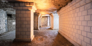
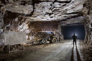
In the south of the Netherlands, around Maastricht and Valkenburg, a soft limestone 70 million years old has been dug out over nearly a thousand kilometres of galleries in total. Here are eleven faces of this underground world: medieval quarries, mushroom farms, wartime shelters, reconstructed catacombs and a NATO bunker.
A vanished sea beneath Limburg
70 million years ago, a subtropical sea covered what is now southern Limburg. Corals, fish, sharks and mosasaurs lived in it. Sediments, algae and shells built up over millions of years, giving rise to a soft limestone nearly 80 metres thick, which the region still calls “marl” out of habit, although the term strictly refers to a mixture of clay and lime.
This limestone comes in three families with quite distinct properties: Maastricht limestone, soft and water-resistant; Gulpen limestone, whose hard beds withstood fire and were used to make oven bricks; and Kunrader limestone, cut rather than sawn, with a rougher surface.
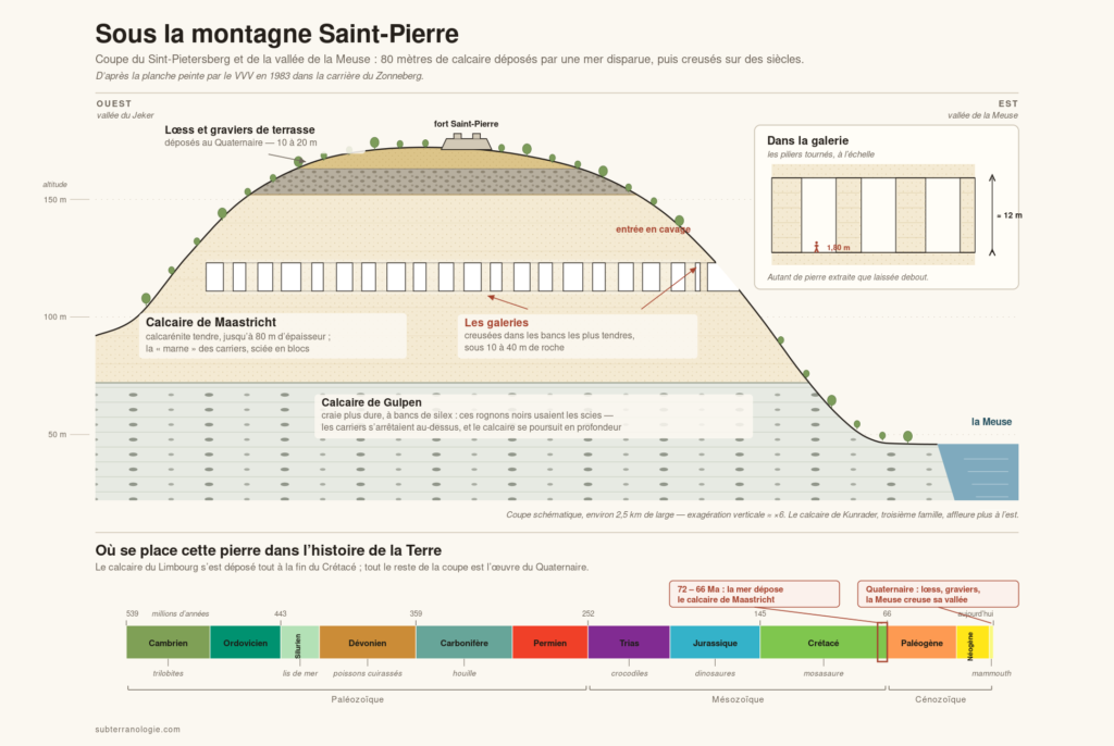
What lies above your head in the galleries: eighty metres of Maastricht limestone, capped with loess and gravels, cut into by the Meuse. Diagram redrawn from the board painted by the VVV in 1983 in the Zonneberg quarry. Click to enlarge.
In the 1770s, the physician Hoffmann unearthed, in the galleries of the Sint-Pietersberg, the fossil skull of a huge marine reptile. Renamed Mosasaurus hoffmanni in his honour, it is today one of the centrepieces of the Muséum national d’histoire naturelle in Paris; local legend has it that it narrowly escaped the French troops in 1794, just as Maastricht was falling under occupation.

Limburg limestone in pictures
Limburg limestone, photo 7 of 9

Limburg limestone, photo 8 of 9

Limburg limestone, photo 9 of 9

The history of extraction
Extraction in blocks only really took hold from the 13th century onwards, driven by the growth of towns. In Maastricht, the second rampart, begun around 1347, swallowed up thousands of “maetstucken” brought in by cart and by boat; a document from 1396 already attests to the trade of berchhouwer, the block breaker.
The work was done with chisel and saw, in total darkness: torch, candle, then oil lamp and finally the carbide lamp from 1910. Around the blokbreker revolved a whole economy: carters, boatmen, blacksmiths for the tools, wheelwrights for wheels that had to carry several tonnes of limestone per load on dirt tracks. Each block breaker recorded on the walls, in red chalk or black pencil, the number of blocks sawn during the day, and these engraved “tallies” can still be read today by the hundreds.
In all, the inventory of South Limburg lists nearly 250 underground quarries, with some thousand kilometres of galleries combined. Only a handful are still in operation today, employing around thirty people for the restoration of monuments.

Detaching a block: from the pick to the chainsaw

The oldest technique did without the saw. The ceilings of the oldest workings bear rounded blow marks, left by the pick used to detach the blocks. Then came the chisel, which cut narrow trenches about one metre deep, vertically and then horizontally, until the stone was cut free around its outline. The early tools are thin and light; those of the 16th and 17th centuries, much heavier, leave distinctly curved impacts.
This evolution can literally be read as you walk. In some entrance galleries from the early 18th century, the shift from one method to the other can be followed over a hundred metres or so: curved impacts first, then straight ones. Block sizes followed, going from about one metre in the old passages to more manageable blocks around 1750. This change came down to a material. A steel much harder than iron had existed for a long time, but remained prohibitively expensive; modern iron and steel making really began in 1817, when John Cockerill modernised the Seraing ironworks, near Liège, with coke-fired blast furnaces.
Chisels then switched to steel and gained a removable tip, which could be taken to the blacksmith on its own. These tips measure sixty to seventy centimetres in the Valkenburg area, and only fifteen to twenty in the Jeker valley: the same trade, two traditions.
Sawing then took over. A set usually comprised three saws, none of them identical to another: neither the shape, nor the number of teeth, nor their spacing was standardised. Each man had his own, suited to the stone, to the method and to his own strength.
The heaviest, with a broad, tapering blade, opened the vertical slots in the face and then cut up the blocks already removed. It could weigh up to six kilos, enough for its weight alone to provide the pressure: the man only had to move it back and forth. It still had to be maintained. The teeth blunted quickly, were filed often, and were set one by one, alternately to the right and to the left. A flint met along the way could ruin a freshly sharpened blade, and many kept an old saw they were prepared to sacrifice to get through the obstacle.
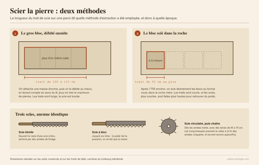
Two methods shared the region. In the first, a very large block was extracted, sometimes more than a cubic metre, then cut up as efficiently as possible to obtain the greatest number of stones while respecting the direction of the bedding: the saw cuts reach one hundred to one hundred and fifteen centimetres. In the second, adopted after about 1750, blocks of the required size were sawn directly from the bedrock; the longest cut does not exceed fifty centimetres, and the saws, shorter, were made taller to regain weight.
Then came the final step. Once the stone had been cut free on five faces, all that remained was to lever it to break the sixth, with the help of a metal wedge slipped under the block. It then had to be tipped over without splitting, because a badly fallen block is a lost block. It was therefore toppled onto a bed of limestone powder prepared to cushion the fall. The local word for this overturned block means “chair”, and the explanation is probably the simplest one: once the stone had landed properly, a man could sit on it to catch his breath, drink a coffee and smoke a pipe.
Mechanisation came late and gradually. A circular saw was in use from the thirties in a quarry in the Jeker valley, another in 1943 on the Belgian side, with blades of forty-five to seventy-five centimetres in diameter; a connecting tunnel between two networks was cut this way. Since the late fifties, industrial extraction has used chainsaws, a technique shared with the quarries of Soissons. As recently as 2001, a new access tunnel was opened with the chainsaw.
Seeing clearly underground
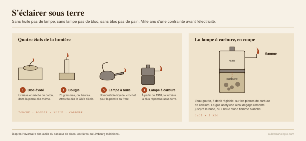
Without light there was no work, and light was expensive. The block breakers, rarely well paid, often paid for it themselves: no oil, no lamp; no lamp, no block; no block, no bread. Saving fuel was not a virtue, it was a necessity.
Torches left no objects behind, but they did leave traces. They had to be rubbed regularly against the wall to remove the charred part, and these black smears can still be seen. They are often found high on the walls, sometimes several metres above the present floor: a valuable clue, as it shows that the gallery has since been deepened. The candle followed, attested here in the 14th century; judging by the candlesticks found, it was the diameter of a little finger, weighed about seventy-eight grams and burned for around ten hours.
Next came oil lamps, first in terracotta and then in metal, whose principle has not changed for thousands of years, and the specifically mining models of the second half of the 19th century, widely distributed here from Germany. When money was short, an empty tin can did the same job.
The real turning point came in 1910, with the carbide lamp. The principle is chemical: water drips, at an adjustable rate, onto lumps of calcium carbide held in the lower reservoir, releasing acetylene, which burns at the nozzle. The flame is white and bright, the lamp sturdy, reliable and cheap.
It came in different versions depending on its use: a high burner for working on the ceiling, a low burner for everything else, a spike model for the mushroom pickers, who moved their lamp dozens of times a day and sometimes drilled holes in the walls to stick it in. Where it was used for a long time, it left its mark: entire ceilings remain stained with black soot.
Dressing, measuring, counting

A block had to be straight, square and to size. Quarrymen carried measuring sticks cut to the required length, thickened at one end to act as a stop, sometimes fitted with an iron point serving as a scriber. The plumb line marked the first face, and the square was used for checking.
A broad flat chisel, held flat under the hand rather than by the handle, was used to plane the top and bottom of the blocks, rough from being broken out, to bring them to the standard format. Workings dressed in this way are strikingly regular, perfectly square and plumb, whereas older workings, from the 14th to the 17th century, remain slanted and rough. Sawing also produced a fine powder that threatened to clog the cut, and a narrow shovel was used to clear it.
Then came the counting. The number of blocks sawn during the day was recorded directly on the wall, engraved or drawn in dark red chalk, sometimes with a black stone similar to slate. These tallies can still be read by the hundreds. The most telling detail lies in their diversity: in the same gallery, in the same period, no two notation systems are identical. Each man had his own way of writing his numbers, perhaps deliberately, so that his tally remained his own.
These pale walls invited inscriptions, and yet early dates are rare. The oldest known one dates back only to 1468, and it was not until the late 1500s that names and years multiplied. The reason is simple: stonecutters were craftsmen, and writing remained the privilege of a few.
Getting the stone out
A quarry can only be worked if the bed can be reached without excessive cost, through a horizontal entrance or a shaft. Everything else is a transport problem, and it begins underground. The blocks were brought out on horse-drawn carts, whose dimensions did not always fit the corners of the galleries: in several places, notches had to be cut into the wall to let the wheel hubs through. Some workings even had a narrow-gauge track taking the blocks to the lime kiln, built not far from the entrance. Outside, wagons and wooden wheels had to withstand several thousand kilos per load on rutted tracks.
These kilns turned limestone into lime, an essential binder in building. Only nineteen remains survive in the whole of South Limburg, and one of them is a unique case in the Netherlands: it is the only one whose exterior is built of limestone. Built in 1933, four years after the stock market crash, and served by a railway line that ran right into the quarry, it operated until 1964 before being saved by a nature conservation association and a regional foundation.
Underground quarrying eventually lost out to open-cast quarrying, which offers direct access to the deposit, the use of heavy machinery and far less dangerous working conditions. A cement works founded in 1924 thus cut into the massif for decades, and was a major employer until the 1970s. The price was high: a hill dug away in whole sections, a damaged landscape and flora, a neighbouring valley dried out by the pumping of groundwater.
A second life: mushrooms, refuges and war
Long before extraction stopped, the empty galleries found other uses. Shelters for livestock in severe cold, hiding places in troubled times, from the end of the 19th century they took in an unexpected activity: mushroom growing. Born in France in the 18th century, the practice reached South Limburg in the second half of the 19th century, with the architect Pierre Cuypers setting up the first troglodyte mushroom farm there around 1890. The conditions are unbeatable: eleven and a half degrees all year round, humidity close to ninety-five per cent, permanent darkness. The process is labour-intensive. The spores are placed on a bed of fresh horse manure, covered with a layer of crushed limestone powder, then lightly watered; six weeks separate sowing from the first harvest. Some installations were far from rustic: steam disinfection cells, heated pre-growth chambers, concrete floors, and in the highest galleries an intermediate floor added to double the growing area. Hundreds of families would make a living from it until an accident, the collapse of the Roosburg at Zichen in 1958, with eighteen dead, sounded the death knell of this underground economy.
War also left its mark. As early as 1794, peasants fleeing with their livestock took refuge in the galleries of the Noord network and built a bread oven there; the discovery of this camp, given away by an escaping pig, is recorded in the report of the French general Poncet. Between 1940 and 1945, the quarries once again became air-raid shelters: in Maastricht, tens of thousands of inhabitants could have taken refuge in them in the event of an alert, in shelters equipped with electrical installations, ovens and flour reserves. Later, at the height of the Cold War, a nuclear shelter was even built in the Noord network.
Eight centuries beneath Limburg, in a few dates
The history of these quarries falls into three periods: a rock laid down by the sea, six centuries of extraction by hand, then a century of reuse, mushrooms, shelters, tourism, once the stone had stopped interesting builders.
Before the quarries
- 70 million years ago A subtropical sea lays down the stone Shells, algae and mosasaur skeletons build up on the seabed. As they compact, they form a limestone 80 metres thick and so soft that it can be sawn by hand; it is what the whole region wrongly calls “the marl”.
The age of the block breakers · 13th–19th centuries
- 13th century Towns demand building stone To extract regular blocks, people stop scraping the surface and dig into the hillside. A trade is born: the blokbreker, the block breaker, who cuts the rock with chisel and saw, by the light of a single candle.
- 1396 The trade enters the archives A Maastricht document mentions for the first time a berchhouwer, literally “mountain cutter”, the name then given to the underground quarryman. Fifty years earlier, the town had already built itself a second rampart with thousands of blocks taken from these galleries.
- 1613 The oldest legible date Engraved in the Fluweelengrot, in Valkenburg. The soft walls lend themselves all too well to inscriptions: over the centuries, they would become a giant visitors’ book, sometimes at the expense of older engravings.
- 1701-1702 A fort above the galleries Baron de Dopff has Fort Sint-Pieter built at the top of the hill. A forty-metre well leads straight down into the quarry: a water reserve in case of siege, and an emergency exit.
- The 1770s A sea monster emerges from the rock The physician Hoffmann unearths the skull of a huge fossil reptile. Taken to Paris during the French occupation of 1794, it is still there: it is the Mosasaurus hoffmanni, one of the most famous fossils in the world.
- 1794 The galleries become a refuge Fleeing the armies of the Revolution, peasants hide for months in the Noord network with their livestock, and bake their bread there. An escaped pig attracts the attention of the sentries and gives everyone away.
The second life of the galleries · 1890-1960
- Around 1890 Mushrooms are grown in the galleries The architect Pierre Cuypers sets up the first underground mushroom farm in Limburg. Eleven and a half degrees all year round, 95% humidity: the empty quarries are perfect. Hundreds of families will make a living from it.
- 1892-1912 Fake Roman catacombs The Diepen family has a copy of the catacombs of Rome dug in Valkenburg, frescoes included. The Italian delegation that comes to the inauguration judges them indistinguishable from the originals.
- Around 1910 The carbide lamp changes everything Sturdy, cheap and much brighter than the candle, it takes over underground. Its soot marks still blacken the ceilings of many galleries.
- 1939-1945 Forty-five thousand people underground The Zonneberg is divided into numbered sectors to house, in the event of bombing, a large part of the population of Maastricht: bread ovens, water points, a chapel and even an infirmary. In the end, the evacuation never takes place.
- 1954 A forgotten quarry becomes an aquarium Rediscovered four years earlier, it reopens as a tourist attraction. It will close amid scandal in 2014, its animals severely neglected.
- 1958 The collapse that stops everything At the Roosburg, on the Belgian side, a vault gives way and kills eighteen people. Underground mushroom growing never recovers: greenhouses above ground take over.
Today
- Since the 1960s Only one quarry is still working The Sibbergroeve still extracts blocks, reserved for the restoration of monuments. Everywhere else, tourism and volunteer associations have taken over, with the delicate task of protecting walls that have been engraved for eight centuries.
A closer look at the Limburg quarries
Everything lies within a very small area: some fifteen kilometres separate the quarries of Maastricht from those of Valkenburg. Two limestone massifs account for most of them, the Sint-Pietersberg, a long ridge wedged between the Meuse and the Jeker, and the slopes of the Margraten plateau cut into by the Geul valley.

Positions plotted from the published coordinates of each of these quarries. Three of the underground sites described below do not appear on this map: they are fragile sites, with no organised visits or supervision, which we prefer not to locate. The Jezuïetenberg and the NATO bunker, about a hundred metres apart in the same Cannerberg massif, have been moved slightly apart so that both remain legible. Click on the map to enlarge it.
Noord and Fort Sint-Pieter
The Noord network, on the northern flank of the Sint-Pietersberg, is the largest and most visited of Maastricht’s underground systems. It was this network that yielded the skull of the future Mosasaurus hoffmanni. It is also the system that suffered most from successive military occupations: the inscriptions left over the centuries by visitors of every nationality tell a story of their own there.
Above the galleries, Fort Sint-Pieter overlooks Maastricht. Daniel Wolff, Baron de Dopff, owner of Neercanne Castle, drew up its plans and ordered its construction in 1701; the work was completed the following year. A forty-metre well, paired with a spiral staircase leading directly into the underground network, secured the water supply during sieges, and also served as an emergency exit. In 1717, Tsar Peter the Great visited the fort; in 1794, its galleries were the scene of fighting between besiegers and defenders. Restored from 1936 onwards and then completely renovated since 2010, the fort can now be visited together with the galleries beneath it.


All the photos of Noord and Fort Sint-Pieter
The Zonneberg
The Zonneberg entrance, cut around 1881, was only connected to the large Sint-Pietersberg network in 1897. Long linked to the Noord, it is now separated from it by a large collapse zone; only the “scout’s hole” (Padvindersgat) still makes it possible, if need be, to pass from one system to the other.
As elsewhere, the galleries housed mushroom farms, and on a smaller scale crops of chicory and cardoons, as an inscription still visible near the entrance shows. But it was the Second World War that left the strongest mark on the site: in 1939-1945 the network was fitted out to take in up to 45,000 inhabitants of Maastricht in the event of bombing. Bakeries, water points, a chapel: an entire underground town plan was put in place, organised in numbered sectors, and the regulations posted on the pillars at the time can still be read.
On the walls, visitors have left remarkable works: the reproduction of a blokbreker at work, or this life-size portrait of Saint Sebastian made by the Maastricht decorator J. Maes for the 512th anniversary of the Guild of Saint Sebastian, in 1921.


All the photos of the Zonneberg
Zonneberg, photo 7 of 22

Zonneberg, photo 8 of 22

Zonneberg, photo 9 of 22

Zonneberg, photo 10 of 22

Zonneberg, photo 11 of 22

Zonneberg, photo 12 of 22

The Fluweelengrot
Beneath the Daalhemerweg, in Valkenburg, lies the Fluweelengrot. Officially dated to 1613 by its oldest known inscription, it is probably much older: several medieval escape tunnels, linked to the nearby castle, run through it, and the block breakers cut across them by chance over the centuries.
It contains one of the finest underground chapels in the Mergelland, fitted out over successive periods of occupation. In 1944, its walls also sheltered an improvised field hospital: dozens of names of wounded Allied soldiers are still engraved there.

All the photos of the Fluweelengrot
The Gemeentegrot
Known well beyond the borders of the Netherlands, the Gemeentegrot, or Valkenburgergroeve, draws thousands of visitors every season, helped also by its Christmas market. Together with the Fluweelengrot, the Wilhelminagroeve and the quarry dug beneath the nearby cable car, it once formed a single, immense network extending under almost the whole of Valkenburg, from Vilt to Oud-Valkenburg.
One of its curiosities has, however, disappeared: its underground lakes, dry since the 1990s, probably because of the pumping of thermal water for the nearby spa, a phenomenon observed at the same time in several other quarries in the region. In 2002, a new 120-metre exit tunnel was cut towards the Plenkertstraat to ensure rapid evacuation in the event of an incident.
The galleries bear the marks of many successive occupations: Art Nouveau sculptures and bas-reliefs carved by passing artists, but also portraits of soldiers and inscriptions dated 1915 and 1944.


All the photos of the Gemeentegrot
Gemeentegrot, photo 7 of 9

Gemeentegrot, photo 8 of 9

Gemeentegrot, photo 9 of 9

The Valkenburg catacombs
Separated from the rest of the Heidegroeve by thick walls, the Valkenburg catacombs have nothing ancient about them: they were entirely designed between 1892 and 1910 by the wealthy industrialist A. Diepen and his sons, to plans by the Limburg architect Pierre Cuypers, who also designed, among other buildings, Amsterdam Central Station. Jan Diepen made many trips to Rome to study their proportions; the frescoes, painted by Pierre Visschers, were judged by the Italian delegation present at the inauguration in 1912 to be indistinguishable from the Roman originals.
Some galleries, originally too wide, were narrowed; others, too narrow, were widened, all to come as close as possible to the ancient model. To see how far this taste for underground staging could go, we have devoted a detailed virtual tour to the Moorish room of the Jezuïetenberg. The Roman temple that once marked the entrance to the catacombs, left abandoned in the 1980s and 90s, was restored in 2015.

The Zwaluwbergroeve
Long divided between two municipalities, whose boundary was redrawn at the end of the 1990s, the Zwaluwbergroeve is today one of the most fragile quarries in the Mergelland. The entrance section is unstable; twenty-five metres further in, almost no pillar has escaped cracking and spalling, and the quarry is doomed, sooner or later, to collapse.
Yet in the first half of the 20th century, it housed the troglodyte workshop of the sculptor Charles Eyck and works made by Montfortian novices, still attested today by the silhouettes and commemorative inscriptions engraved on its walls. An underground flood once covered the central part of the quarry with nearly 1.80 metres of mud, as shown by the brown line still visible on the pillars. Nicknamed the “pilots’ cave”, it hid Allied airmen and draft evaders during the Occupation.

All the photos of the Zwaluwbergroeve
The Sibbergroeve, the last working quarry
In Sibbe, the Sibbergroeve is today the largest underground network still being worked in either the Netherlands or Belgium, with some ninety kilometres of galleries combined. The exceptional quality of its limestone, which local jargon calls “Subbersjtein” rather than mere marl, has for decades made it one of the only sources of blocks for the restoration of monuments in the region.
This good-quality layer is thin, however: the resulting galleries are barely more than two metres high. When block breakers came across a poor seam, the foremen sometimes made them dig, as a punishment, “strafpijpen”, long rising or descending test tunnels, cut blindly in search of better rock, often with neither result nor pay at the end.

All the photos of the Sibbergroeve
The Doornkuilgroef underground aquarium
This quarry long remained absent from official documents. Sealed off in the second half of the 19th century by what was probably a storm that flooded its entrance with mud, the quarry was forgotten for nearly a century, before being “rediscovered” in 1950.
Four years later, it reopened as an underground aquarium, the Grottenaquarium. The attraction came to an inglorious end: in March 2014, hundreds of fish and dozens of reptiles and amphibians were found there severely neglected and had to be removed by animal welfare organisations. A few years later, the police dismantled a cannabis plantation there, clearly better looked after than the previous occupants.

All the photos of the Doornkuilgroef
The Elzenveldgroeve and the Meerberg
The present site is the result of the merger, in 1946, of two separate quarries connected by a descending tunnel, the older and smaller one on one side, the larger on the other. The original entrance of the Elzenveldgroeve, judged “in good condition” by the mining engineer De Jongh in 1926, a rare verdict in his reports, disappeared in 1949, swallowed up by a neighbouring open-cast quarry. The remaining two thirds of the galleries followed in the 1950s and 60s; what survives today are sections of wall still streaked with saw marks, visible from the open-cast quarry.
The more recent part, worked through the Meerberg entrance, stands out for its very regular, carefully sawn galleries, where blocks were extracted and mushrooms grown until the mid-1960s. In 1944, the German occupiers even planned to manufacture parts there for a new type of fighter, the Natter, a project that came to nothing.

All the photos of the Elzenveldgroeve and the Meerberg
The NATO bunker under the Boschberg
Under the Boschberg, a former section of quarry was converted, at the height of the Cold War, into an underground NATO base connected by tunnel to the neighbouring Kleine Keel quarry. Military signage in English, a medical centre, dormitories: the conversion borrows the typical look of the Atlantic Alliance’s command installations of the time, carved directly into the Limburg limestone. The idea was not an isolated one: the Noord section of the Sint-Pietersberg, a few kilometres away, also received a nuclear shelter during the same period.

All the photos of the NATO bunker

The Jezuïetenberg
The Jezuïetenberg would deserve an article of its own: its galleries contain one of the most spectacular decorations in the Mergelland, a room inspired by the Alhambra in Granada, entirely painted with polychrome Moorish motifs, with a pool and colonnades. We have devoted a detailed virtual tour to it; here is its main room, and the details of what it depicts.

This room is a reconstruction of the Court of the Lions of the Alhambra in Granada, carved and then painted directly into the limestone. Everything in it is fake except the rock: the columns are carved from the marl, the “azulejos” are painted, and the back of the great arch is a trompe-l’œil that extends the room in perspective. Here is how to read it.
All the photos of the Jezuïetenberg
Underground tourism lives on
As early as the 17th and 18th centuries, distinguished foreign visitors were already exploring the Sint-Pietersberg and leaving their names engraved on its walls. The movement grew in the 20th century: several hundred thousand tourists go down beneath South Limburg every year, guided through an underground world that the author D.C. van Schaik was the first to document, in 1938.
This success has a downside: on the busiest routes, inscriptions several centuries old have been irreparably damaged by unscrupulous visitors, when they have not simply been covered over to make way for a more recent commemorative plaque. Fortunately, the current trend is towards preservation: volunteer associations, access badge systems and consolidation work have multiplied in recent years so that this heritage, shaped in places over eight centuries of block breaking, continues to exist beyond the next tourist.

These photographs are part of the underground heritage photography collection.